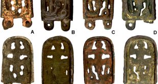
HANOVER, NEW HAMPSHIRE—CNN reports that a team of researchers led by Jesse Casana of Dartmouth College has spotted hundreds of Roman-era structures in declassified photographs of Iraq and Syria taken by spy satellites during the Cold War. “Agriculture and urbanization have destroyed a lot of archaeological sites and features to a shocking degree,” Casana said. “This old imagery allows us to see things that are often either obscured or no longer extant today,” he explained. In the 1920s and 1930s, French archaeologist and Christian missionary Father Antoine Poidebard conducted an aerial survey of the area and identified 116 Roman forts. He thought the structures had been situated in a north-south line along the eastern border of the Roman Empire as a line of defense. The new study identified hundreds of forts spread over an area of approximately 116,000 square miles, and suggests that they may have served as outposts for caravans travelling Roman roads between the second and sixth centuries. Continuing investigation is likely to lead to the discovery of additional Roman forts, Casana concluded. Read the original scholarly article about this research in Antiquity. For more on using declassified surveillance satellite photos to identify ancient fortifications, go to “Spying the Past from the Sky.”
Source: archaeology.org