LiDAR (light detection and ranging) has documented 26 settlement sites, including two remarkably large, of the Casarabe culture in the Llanos de Mojos, Bolivia. The discovery challenges the view of Amazonia as a historically pristine landscape, but was instead home to an early urbanism created and managed by indigenous populations for thousands of years.

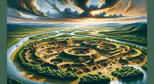
The site of Cotoca in the Llanos de Mojos region, Bolivia. Image credit: Heiko Prümers / DAI.
During the Late Holocene epoch, pre-Hispanic agriculturalists in the Llanos de Mojos, Bolivia, transformed seasonally flooded Amazonian savannahs into productive agricultural and aquacultural landscapes.
The Casarabe culture developed in this region between around 500 CE and 1400 CE, spreading over an area of 4,500 km2.
“We long suspected that the most complex pre-Columbian societies in the whole basin developed in this part of the Bolivian Amazon, but evidence is concealed under the forest canopy and is hard to visit in person,” said University of Exeter’s Professor Jose Iriarte.
Using LiDAR data, Professor Iriarte and his colleagues documented in detail the two large settlement sites and 24 smaller sites of the Casarabe culture, of which only 15 were previously known to exist.
They found an unprecedented array of elaborate and intricate structures unlike any previously discovered in the region, including 5-m-high terraces and 21-m-tall conical pyramids.
Crucially, the researchers maintain that these settlements were constructed and managed not at odds with nature, but alongside it — employing successful sustainable subsistence strategies that promoted conservationism and maintained the rich biodiversity of the surrounding landscape.
“Our LiDAR system has revealed built terraces, straight causeways, enclosures with checkpoints, and water reservoirs,” Professor Iriarte said.
“There are monumental structures are just a mile apart connected by 965 km of canals long raised causeways connecting sites, reservoirs and lakes.”
“LiDAR technology combined with extensive archaeological research reveals that indigenous people not only managed forested landscapes but also created urban landscapes, which can significantly contribute to perspectives on the conservation of the Amazon.”
“This region was one of the earliest occupied by humans in Amazonia, where people started to domesticate crops of global importance such as manioc and rice. But little is known about daily life and the early cities built during this period.”
“These ancient cities were primary centers of a regional settlement network connected by still visible, straight causeways that radiate from these sites into the landscape for several kilometers. Access to the sites may have been restricted and controlled,” said University of Exeter’s Dr. Mark Robinson.
“Our results put to rest arguments that western Amazonia was sparsely populated in pre-Hispanic times.”
“The architectural layout of Casarabe culture large settlement sites indicates that the inhabitants of this region created a new social and public landscape.”
“The scale, monumentality and labor involved in the construction of the civic-ceremonial architecture, water management infrastructure, and spatial extent of settlement dispersal, compare favorably to Andean cultures and are to a scale far beyond the sophisticated, interconnected settlements of Southern Amazonia.”
The team’s results appear today in the journal Nature.
_____
H. Prümers et al. Lidar reveals pre-Hispanic low-density urbanism in the Bolivian Amazon. Nature, published online May 25, 2022; doi: 10.1038/s41586-022-04780-4
Source: sci-news.com